THE RIVER RAISIN PROJECT:
An Interdisciplinary Study Of A Human-impacted Watershed
Transformation of the landscape by agriculture and settlement is amongst the most significant of human impacts on running water environments. In parts of the Midwestern USA, the long post-settlement trend towards agriculture and dis
crete villages is being replaced by a reduction in farmed land 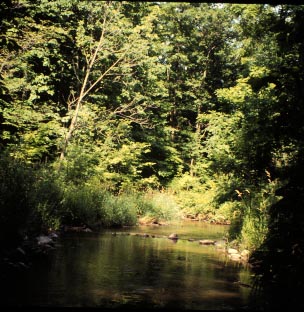 and increased suburban development. This poses both new challenges and new opportunties to watershed management.
We are using a geographic information systems (GIS) to develop an interdisciplinary model of land use changes and their effects on the mainstem km) and tributaries of the River Raisin in southeast Michigan. and increased suburban development. This poses both new challenges and new opportunties to watershed management.
We are using a geographic information systems (GIS) to develop an interdisciplinary model of land use changes and their effects on the mainstem km) and tributaries of the River Raisin in southeast Michigan.
Spatial data layers for the watershed include soils, land cover from 1978/85 flyovers, a presettlement land cover only partially completed, and 1968 vs. 1988 for selected townships. Overall, the watershed (2776 km2) is 70% zoned for farmland, but the cat
chments of various tributaries range from 50% to 90% agricultural land use.
Comparison of 1968 to 1988 land covers for 10 counties revealed declines in agricultural use, steep increases in urban use, and an increased amount of riparian forest cover.
Analysis of land parcel number and size in two townships revealed farm amalgation and increasing numbers of small parcels indicative of suburbanization, although patterns vary with location within the watershed. Census data establish that the average age
of farm owners in increasing, suggesting that the trend away from agriculture will accelerate in the near future.
A non-point source water quality model (AGNPS) indicates that "hotspots" of soil erosion can be identified from soil, slope and land cover data. Field sampling corroborates that sediment loss is much higher from heavily farmed areas, and model runs using
pre-settlement vegetation provide a baseline against which to evaluate current sediment loss.
Habitat, invertebrate and fish surveys at 20-30 sites throughout the watershed document a wide range in measures of habitat and biological assemblages that are strongly suggestive of a chain of causality from land use to stream ecosystem status. GIS is
a useful tool for integration of data in a landscape/ watershed analysis.
|