
PLANET EARTH:
PROBING BEYOND THE SURFACE
by Rebecca Hotz and Kristen Schmidt
Chapter Outline
I. Introduction: Why You Should Care
II. The Composition of the Earth
III. Differing Physical Properties of the Earth
- Mesosphere
- Asthenosphere
- Lithosphere
IV. Types of Crust
V. Plates of the Earth
VI. Plate Tectonics
VII. Plate Boundaries
- Divergent
- Convergent
- Transform
VIII. Summary
IX. Closing Thoughts and Comments
X. Glossary
XI. Work Cited
XII. Additional Readings
Introduction
Although humans spend every day on the crust of
the earth, we tend to take for granted the incredible physical features
that the earth displays. For example, downhill skiing would be impossible
without hills and mountains. But why were these mountains formed? It is
easy to assume that they were not formed for the sole purpose of downhill
skiing. The strength of the earth's movements are amazing. Natural disasters
such as earthquakes are caused by the movement and heat of material below
the earth's surface. To understand the formation of physical features of
the earth and natural disasters, we must probe beyond the surface of the
earth. The inner layers of the earth do have an effect on our daily lives,
and it is important to know what is beneath the surface that we live on
and how it works.
The Composition of the Earth
The earth contains three layers of different composition.
The innermost is the core, the densest of the three layers. It is a spherical
mass, composed largely of metallic iron, with smaller amounts of nickel
and other elements. The middle layer is the mantle, made of dense, rocky
matter. The outermost layer of the earth is the crust, which is the thinnet
of the three layers. The core, mantle and crust are different sections
of the earth because of the different composition they have.
Differing Physical Properties
of the Earth
The earth also contains layers of differing physical
properties. Examples of these properties are rock strength and solid versus
liquid. Changes in physical properties differ from changes in composition
because physical properties are controlled by temperature and pressure.
These different properties divide the mantle and crust into three strength
regions.
Mesosphere
The lower part of the mantle where rock is very
highly compressed is called the mesosphere. It is located from the core-mantle
boundary to a depth of about 350 km. The pressure in the mesosphere is
so great that even though the rock is hot, it is solid and considerably
more rigid than the rock on top of it.
Asthenosphere
The asthenosphere is the next layer within the
mantle. It has the same chemical composition of the mesosphere but differing
physical properties. In the asthenosphere, the balance between temperature
and pressure is such that rocks have little strength. The rocks in the
asthenosphere are weak and easily deformed, like butter or warm tar. The
asthenosphere is also known as the "low velocity" zone of the
mantle because seismic waves slow down as they pass through it. This property
tells us that the asthenosphere is composed of partially molten rock slushlike
material consisting of solid particles with liquid occupying spaces in
between. Although the asthenosphere represents no more than six percent
of the mantle, the mobility of this layer allows the overlaying lithosphere
to move.
Lithosphere
The lithosphere is the top layer of the physical
properties divisions. It begins at the uppermost level of the mantle and
includes the entire crust. It ends with the surface of the earth. In the
lithosphere, the rocks are cooler, stronger, and more rigid than the asthenosphere.
It is rock strength that differentiates the lithosphere from the asthenosphere.
The differences in strength between rock in the lithosphere and rock in
the asthenosphere is a function of temperature and pressure. The lithosphere
has a chemistry composition far different from the planet as a whole. Although
rich in silicon like the mantle, it has far higher iron and magnesium contents
and far lower aluminum, sodium, and potassium contents. (See figure 1).
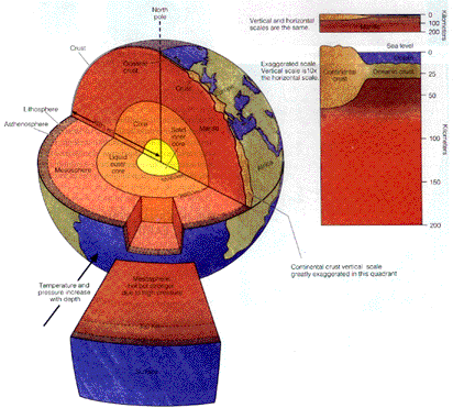
(Picture taken from The Dynamic Earth: An Intorduction
to Geology.)
Figure 1: Division of the earth.
Types of Crust
There are two types of crust that make up the
surface of the lithosphere. One is oceanic crust and the other is continental
crust. The ocean crust portion of the Earth's outer skin is fundamentally
different in composition from the continental portion.
Continental Crust
The continents are constructed largely of rocks
called granite, the ocean floor consists of rocks called basalt. The chemical
composition of these two types of rocks is surprisingly different. The
granitic crust is composed mostly of the elements aluminum and sodium along
with potassium. Feldspar and quartz are the chief minerals in granite.
A mica, either muscouite or biotite, is usually present, and many granites
contain scattered bits of hornblende. Granite is intrusive igneous rock
that is formed when magma solidifies within the crust or mantle. Another
difference in granite and basalt is age. The granites of the continents
range back to about 3.8 billion years but the ocean's basalts rarely exceed
.1 billion years of age. This is because the oceanic crust is constantly
being renewed with molten material that climbs upward from the mantle.
Oceanic Crust
The ocean basins take up 71 percent of the earth's
surface, and the average depth of the oceans is 3.7 km. The other 29 percent
of the earth's surface is continents, which have an average height of .8
km above the earth's surface. The reason that the continents stand higher
than the ocean basins is that the oceanic crust is more dense (3.2 g/cm3)
than the continental crust (2.7 g/cm3). Because the lithosphere is floating
on the asthenosphere, those portions of the lithosphere capped by the lighter
continental crust stand higher than those capped with oceanic crust. In
contrast to granite, the chemical composition of basalt is closer to the
composition of the mantle, with larger amounts of iron and magnesium than
granite. Basalt is extrusive igneous rock, which is formed from the solidification
of lava. The minerals pyroxine and olivine make up over fifty percent of
b asalt.
Plates of the Earth
The lithosphere is not a continuous layer. Instead,
the lithosphere is divided up into a number of huge plates that move in
relation to one another. Some plates carry continents with them, while
others carry only oceanic crust. Plates move over the surface of the earth
about as rapidly as human fingernails grow. Although this may seem slow,
the progress of plates over millions of years has been considerable. Many
have moved as far as 500 or even 1000 kilometers in ten million years.
It is believed that at the begining of the earth, the continents were all
locked into a huge landmass, called Pangea. They broke apart and gradually
drifted to their present positions. The plates are currently drifting sideways
at rates up to 12cm a year. However, it is not just the continents that
move, it is the lithosphere also.
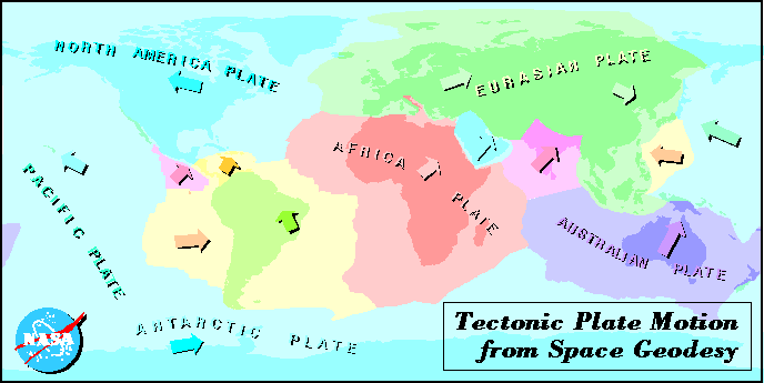
(Picture taken from NASA)
Figure 3: The earth's plates,plate divisions, and direction in
which they are moving.
Plate Tectonics
The motion of the earth's plates is called plate
tectonics. Tectonics is derived from a Greek word "tekton" which
means "carpenter" or "builder". Tectonics is the study
of the movement and deformation of the lithosphere. Plate tectonics is
the only hypothesis ever proposed that explains all of the earth's major
surface features on the continents and ocean basins.
Motion of the Plates
What is the cause behind the motion of the plates?
We know that the asthenosphere and the lithosphere are closely bound together.
If one part moves, the other part must move with it. We know that the lithosphere
must have kinetic energy in order to move, and the source of this kinetic
energy is the earth's internal heat. The mantle is solid rock, but is subject
to convection currents when a local source of heat causes a mass of rock
to become heated to a higher temperature than surrounding rock. The heated
mass expands, becomes less dense, and rises slowly. To compensate for the
rising mass, rock that is cooler and denser must sink downward. The rate
at which heat reaches the earth's surface can be accounted for only if
convection in the mantle brings heat from the deep interior. It is hard
to imagine how convection motions alone are responsible for moving entire
plates. Most scientists believe that the lithosphere movement is due to
a number of reasons and convection is only one of them. However, convections
the process that keeps the asthenosphere hot and weak by bringing up heat
from the mantle. Therefore, convection is essential for plate tectonics.
Plate Boundaries
Divergent
Divergent plate boundaries or otherwise called a spreading axes forms
when plates split and pulled apart. When rifting occurs, spreading extends
into the continent, and the continent is split apart. The continental crust
that has been split apart moves with the diverging plates and creates an
ocean basin in what used to be the rift zone. Divergent plate boundaries
are characterized by tension which creates block faulting, and fractures.
Another characteristic of divergent plates boundaries are fissures.
Fissures are created by basaltic magma that are created by the melting
of the mantle. Basaltic magma is injected into the fissures or extruded
as fissures eruptions. The magma cools and becomes part of the moving divergent
plates. Fissure eruptions along plate boundaries are the most active volcanic
areas on the face of the earth. Although divergent plates boundaries represent
one of the most active volcanic areas, the eruptions are characterized
by quiet fissure, which occur beneath the sea . Volcanism that occurs on
divergent plate boundaries is important because it tells us that much of
the Earth's surface was created by volcanic activity.
Most divergent plate margins are submerged beneath the sea, and therefore,
cannot be easily observed. Other divergent plate boundaries occur in rift
zones near Africa and Western North America. Through the new technology
of seismic�reflection, images of divergent plate boundaries can now be
seen. The figure 3 shows a series of fault blocks which are produced by
stretching and thinning of the lithosphere. The curved fault planes are
created by tension. Fault blocks are then tilted, and produces a series
of ridges and troughs. The troughs are partially filled with sediment,
which is a result of erosion and depositation that occurs with fault displacement.
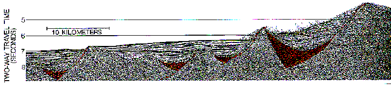
(Picture taken from The Earth's Dynamic Systems.
6th ed., page 438.)
Figure 3: Seismic Image of a divergent plate margin: This image
shows faults blocks that are created by the stretching and upward arch
of the upper layer of the continental crust. Ridges are created by the
fault blocks sliding down curved fault planes. Sediment are eroded off
fault blocks, filling troughs, and are then deposited into lake basins.
Continental rifting in different stages can be found around the world.
During the first stage long linear valleys, partially occupied by lakes
are huge down dropped fault blocks, resulting from the original tensional
stress. As a result, magma rises from the mantle into the rift zones thus
creating volcanism. An example of this stage is the rift valleys in east
Africa. The Red sea is an example of a more advanced stage of rifting.
The Arabian Peninsula has been separated from Africa. As a result a new
linear ocean base is being created. An even more advanced stage of continental
drift and sea floor spreading is demonstrated by the Atlantic Ocean. The
American continents have been moving away from Africa and E urope and are
now separated by thousands of kilometers. The mid �Atlantic ridge represent
the boundary for the two diverging plates.
Convergent
Convergent plates boundaries, or otherwise known as subduction zones,
occurs when plates collide and one plate is pushed under the other. This
activity is related to major geological processes such as: igneous activity,
mountain building, and crustal formation. The geologic formation depends
upon the type of crust involved in the collision.
Convergent boundaries containing both oceanic crust, results in one
plate being pushed under the margin of the other. The subducting plate
is pushed down into the asthenosphere, where it is then heated and absorbed
into the mantle. If a plate consists of a continent, the lighter continental
crust does not subduct under the oceanic crust. Instead, it overrides the
oceanic plate. If both converging plates consist of continental crust,
neither one subducts into the mantle, one continental crust can override
the other for a minimal distance. The two continental crusts are then compressed
and "fused" or "welded" together which creates a mountain
range . The converging zone between two plates is a zone of deformation,
resulting in mountain building and metamorphism. If the overriding plate
is comprised of continental crust, it forms a folded mountain belt, which
causes metamorphism deep in the root of the mountain.
In subduction zones, oceanic crust contains three layers, unconsolidated
sediments, lithified sediments, and basalt, which can be seen on seismic
reflection profiles in figure 4. The unconsolidated sediment layers are
scraped off by the subducting plate, which creates a accretionary prism.
The consolidated sediments and the underlying basalt stay together for
approximately 50 kilometers beyond the base of the ridge. This illustrates
that some sedimentary rock has been subducted. The remaining soft sediments
are being deformed into a m�lange.
The water that was initially in the oceanic crust escapes and goes into
the overlying wedge of the mantle. As a result of this process the melting
temperature of the overlying mantle is lowered, which produces the distinctive
magmas of subduction zones.
The magma are characterized by andesites, although more silicic magma
can also be found in subduction zones. As hot magma rises into the crust,
it melts crustal minerals. This crystallizes the magma and causes it to
be more silicic. This process produces a chain of volcanoes located in
a mountain range belt or an island arc in the plate. Most of the time,
magma pushes its way into the deeper regions of the mountain belt producing
batholiths. This igneous activity, whether it be intrusive or extrusive,
adds new material to the continental plate. Another result of convergent
plate boundaries is back�arc spreading , which is an extension and spreading
of the sea floor behind the island arc. This process is a result of complex
convection in the asthenosphere above the subducting plate or by pulling
away from the
adjacent plate. Either one of these processes could cause regional
tension which forms a back arc basin. A back-arc basin is characterized
by crustal thinning and block faulting.
The back-arc region is similar to a major spreading axis, but there
are some differences between the two. In back-arc spreading, the floor
of the basin is young, and sediments are thin. In addition, back arc spreading
heat flow is high with no well�defined ridge or rift valley.
Transform
The third type of plate boundary is called a transform fault. These
zones are characterized by horizontal shearing. Plates slide past each
other without creating or destroying lithosphere. Transform faults boundaries
create a special type of fault, called a strike�slip fault. This fault
is characterized by the horizontal and parallel movement of fault blocks
along the fault. Transform refers to the motion between plates, because
it is transformed at the ends of the active part of the fault.
Figure 5 shows a seimic image of a transform fault boundary, which meets
a mid-oceanic ridge. On each side of the fracture zone, block of crust
with small age differnces are present. In addition, close to the fracture
zone, the crust becomes thinner.
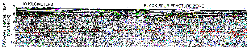
Picture taken from The Earth's Dynamic Systems. 6th ed.,
page 439)
Figure 4: Seismic image of a transform fault boundary: Displayed
above is the Black Spur fracture zone located about 1000 km east of Flordia.
Note the discontinuity along the fracture zone where the two plates are
sliding past each other.
Transform faults join ridges to trenches and trenches to trenches.
Transform faults move parallel and therefore divergence and convergence
do not happen at this type of boundary. These plates slide along a fracture
system and their movement produces both fracturing and seismic activity.
Summary
There are three compositional layers in the earth,
the core, the mantle, and the crust. The physical properties, of the outer
portion of the earth produces the mesosphere, the asthenosphere, and the
lithosphere. The lithosphere contains two different types of crust: oceanic
and continental. The chemical composition of these types of crusts are
different. The ocean floor is composed of basalt and the continent portion
is made primarily up of granite. The lithosphere is not a continuous layer,
but it is broken into many different plates. These plates are not stationary
moving over the face of the earth. The movement behind these plates is
thought to be caused by heat loss and convection in the mantle.
There are three types of plate boundaries as shown in figure 6: divergent,
convergent, and transform. Divergent margins are found between two plates.
Divergent margins occur when tensional stress caused the plates to split
and be pulled apart . Convergent plates or otherwise known as subduction
zones occur when two plates collide and one is subducted and forced down
into the mantle. The topographic features created by this type of boundary
depend upon the type of crust involved. Transform faults margins are characterized
by shearing, which is a result of two plates sliding past each other without
convergence or divergence taking place.
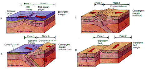
(Picture taken from The Dynamic Earth:
An Introduction to Geology. 3rd ed., page 32.)
Figure 5: (A) Divergent margin which is characterized by a mid-oceanic
ridge. (B) Convergent plate margin involving subduction. This type of fault
produces seafloor trenches. (C) Colliding convergent margin, which creates
moutain building. (D) Transform fault margin, which has no topographic
feature, but is characterized by preferential erosion along the fault.
Closing Thoughts and Comments
As humans, many of us walk on the face of the earth and take for granted
the topography, by not knowing how it was created. Hopefully , through
this paper, by discussing the earth's asthenosphere, lithosphere, convection
in the mantle and the three different types of plate margins we have shed
some light on how some of the earths topographic features have been made
and what is the cause behind natural disasters such as earthquakes and
volcanism. Understanding our earth, what it is composed of and how it works,
will help us continue to live on this wonderful habitable planet called
Earth.
Glossary
Andesites: A fine grained rock made up of dirorite.
Asthenosphere: The part of the mantle where rocks are ductile,
they have little strength, and easily become deformed. It lies at a depth
of 100 to 350 km below the earth's surface.
Basalt: A fine-grained igneous rock with the composition of
gabbro.
Continental Drift: The movement of the continents over the earth's
surface.
Mesosphere: The region between the base of the asthenosphere
and the core mantle.
Lithosphere: The outer 100 km of the earth. Rocks there are
harder and more rigid than those in the lithosphere.
Seismic Waves: Elastic disturbances that move out from the earthquakes
focus.
Granite: A course grained igneous rock that contains quarts,
and feldspar. Potassium feldspar is more abundant than plagioclase.
Plate Tectonics: The process by which the lithosphere moves
over the asthenosphere.
Divergent Plate Boundaries: Occurs in the lithosphere when two
plates move apart. It is also called a spreading axes.
Convergent Plate Boundaries: A zone where plates move toward
each other.
Convection: The process which hot , less dense materials rise
upward and are replaces by colder more dense, material. This in turn creates
the convection current.
Subduction zones: (Also called a convergent margin or plate
boundary.) The linear zone where the plate of the lithosphere sinks down
into the asthenosphere.
Subduction: The process by which the cold lithosphere is in
into the asthenosphere.
Work Cited
Broecker, Wallace S. How to Build a Habitable Planet. New
York: Eldigio Press, 1985.
Hamblin, Kenneth W. The Earth's Dynamic System. 6th ed. New York: MacMillian,
1992.
Skinner, Brian J and Porter, Stephen C. The Dynamic Earth. An Introduction
to Physical Geology. 3rd ed. New York: John Wiley & Sons, Inc., 1995.
Stanley, Steven M. Exploring Earth and Life Through Time. New York:
W.H. Greeman and Company, 1993.
Additional Readings
Bonati E., "The Rifting of Continents, "Scientific
America, March 1987.
Gass, I.G., "Ophiolites" Scientific America, August 1982.
MacDonald, K.C. and P.J. Fox, "The Mid-Ocean Ridge, " Scientific
America, June 1990.
Sullivan W., Continents in Motion, America Institute of Physics, New
York, 1991.