RESEARCH
Research areas:
-
•Amazon ecohydrology
-
•Spatial variability of soil moisture
-
•Coupled hydrology-hydrodynamics model
-
•Erosion and sediment transport
-
•Climate projections and uncertainty
-
•Topography and vegetation dynamics in semiarid areas
-
•Canopy-scale heterogeneity
There is perhaps no clearer refutation of the so often heard thesis according to which to explain is to infer, than the fact that explanation occurs so often, or even nearly always, through model-building.
Leo Apostel
In many hydrologic applications flood routing can be regarded as propagation of shallow water waves. This process can be mathematically investigated with the Saint-Venant equations (dynamic wave) or with their simplified versions, e.g., the kinematic and diffusive approximations. The dynamic wave model formulation requires detailed watershed topographic and channel cross section data as well as poses several serious numerical challenges to solve, when continuously applied over the storm-interstorm period. Therefore, scientists have historically developed methods based on the kinematic wave model that can be applicable for problems of flood wave propagation in steep terrain due to its computational efficiency. However, simplified models has several limitations for applications for cases of flow over flat slopes, flow into large reservoirs, strong backwater conditions, flow reversals, and flows with boundary conditions. This seriously constrains the range applicability and prediction skills of such models in the changing world.
This study develops a new coupled model that integrates a physically-based watershed hydrological model and an open flow hydrodynamic model based on the dynamic routing method. The hydrology model with the kinematic approximation is based on the existing tRIBS, TIN-Based Real Time Integrated Basin Simulator. This numerical model employs a multiple resolution mesh by using triangulated irregular network (TIN) to resolve watershed and has the ability to explicitly utilize a variety of data such as topography, soil type, land use and vegetation. tRIBS input in terms of hydrometeorological forcing include precipitation, radiation, temperature, atmospheric turbulence, etc. The spatial and temporal variability of runoff, interception, surface soil moisture, evaporative flux, infiltration, and groundwater table position are simulated. The computed runoff is used as input to the hydrodynamic open flow model. The hydrodynamic open flow model (OFM) with the dynamic approximation utilizes the two- dimensional Saint-Venant equations with a finite volume method in order to predict various flow patterns.
OFM is able to compute the depth of flow, velocity field, the location and elevation of the free surface, turbulent characteristics and shear stresses near the bottom. In particular, OFM can accurately calculate whether the regions simulated are wet or dry, for a variety of boundary conditions and slopes. This information can be used to estimate sediment transport flux, which makes feasible studies of the impacts of watershed hydrology on bed morphology.
The two figures above show the spatial variability of the flow depth at a specific time with the same forcing in different synthetic domains, which is generated by several types of runoff in the saturated and unsaturated zones. The simulated temporal and spatial results enable one to know how the given precipitation affects on the location and magnitude of the runoff and flooding.
tRIBS-OFM
A Parsimonious Dynamic Flow Model for Hydrological Applications
This research is focused on developing novel approaches to hydrological/hydrodynamic modeling. A significant problem in modeling water flow over realistic domains is the complexity of the underlying equations and the computational expense of solving them. Many hydrological models use simplified versions of the full equations such as kinematic wave theory to avoid this issue, but these simplifications limit the accuracy and applicability of the model. Additionally, the conditions that determine the applicability of a theory may change over space and time for a given domain and simulation period. This research develops a hydrodynamic model that will have the capability to choose between solving the full dynamic equations or a simplified version, based on the flow regime and terrain characteristics of the problem.
The above movie illustrates a simulation in which the Biosphere-2 domain is used for running the hydrodynamic model. Rainfall excess rate of 100 mm/hour is assumed and all of the boundaries are set as no-flow boundaries. The color depicts the height of the water level that increases as water backs up from the downstream boundary.
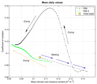
Using the design characteristics of the Biosphere 2 hillslope experiment, this study investigates aspects of soil moisture spatial and temporal variability in a zero-order catchment of a semiarid climate. The hydrological response of the domain exhibits a particular structure, which depends on whether topography-induced subsurface stormflow is triggered. The occurrence of the latter is conditioned by topography, soil depth, and pre-storm spatial distribution of moisture. As a result, a non-unique behavior of soil moisture spatial heterogeneity emerges, manifested through a hysteretic dependence of variability metrics on mean water content. Further, it is argued that vegetation dynamics impose a ``homogenizing'' effect on pre-storm moisture states, decreasing the likelihood that a rainfall event will result in topographic redistribution of soil water. Consequently, post-rainfall soil moisture dynamics associated with the effect of topography that could lead to the enhancement of spatial heterogeneity are suppressed; a potential ``attractor'' of catchment states emerges. The study proposes several hypotheses that will be testable within the framework of the long-term hillslope experiments.
This research is carried out in collaboration with Dr. Simone Fatichi at ETH, Zurich, Switzerland.
Spatial variability of soil moisture in complex terrain
Vegetation effects on spatiotemporal variability of subsurface flow
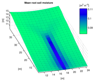
We are currently studying the effects of biota on subsurface redistribution of soil water and the formation of variable source areas. A movie below illustrates a downstream flux (as integrated value between soil surface and bedrock boundary) for a bare soil case. Note that the high redistribution flow contributes to the formation of variable source areas following rainfall events.
BARE SOIL: climate of Atlanta (GA)
Vegetation effects on geomorphic processes and sediment transport
Plants exert resistance effects on flowing water in hillslopes and channels thereby affecting not only the flow hydrodynamics but also the processes of erosion and sediment transport. Our group together with colleagues at the University of Palermo (Italy) and the University of Washington is addressing the corresponding effects scaling up from the plant stem, to the plot, to the hillslope, and to the watershed scale. We have recently developed a parsimonious model of geomorphic processes at the catchment scale, tRIBS-Erosion, that couples the catchment hydrological response to the processes of fluvial and diffusion erosion, sediment detachment, deposition and transport. Furthermore, we are developing a fully physically-based model of erosion that is based on 2-D model dynamic wave flow model capable of characterization the flow field in space as well as explicitly inferring shear stress exerted by flow on soil surface. Video clips below illustrate artificially exaggerated rates of erosion in a 4 sq. km catchment that is used as our virtual testbed.
This research is carried out in collaboration with Prof. Valerio Noto and Dr. Antonio Francipane at the University of Palermo, Italy.
The video clip on the left illustrates dynamics of the flow with the initial condition of static 1 m deep water situated in a tank. The sides of the tank are lifted and the boundary condition on each side of the rectangular domain becomes free overfall. The dynamic wave model permits a consistent simulation of this scenario (where inertia-free or kinematic wave methods would fail).
An illustration of flow propagation from the upstream boundary to a downstream reach. A steady-state flow is rapidly achieved. The simulation reproduces an actual scenario of water flow in a mountainous brook located in British Columbia (Canada). DEM data are courtesy of Piotr Cienciala and Prof. Marwan Hassan (UBC).
This material is partially based upon work supported by the National Science Foundation under Grant No. 0911444.
This material is partially based upon work supported by the National Science Foundation under Grant No. 0911444.
This study has been supported by the Graham Environmental Sustainability Institute at the University of Michigan through the grant “Assessment of the Impact of Watershed Changes on Estuarine Morphology and Aquatic Life”.
Large areas of Amazonian evergreen forest experience seasonal droughts extending for three or more months yet show maximum rates of photosynthesis and evapotranspiration during dry intervals. This apparent resilience is belied by disproportionate mortality of the large trees in manipulations that reduce wet season rainfall, occurring after 2-3 years of treatment. The goal of this study is to characterize the mechanisms that produce these contrasting ecosystem responses. A mechanistic model is developed based on the ecohydrological framework of tRIBS+VEGGIE. The model is used to test the roles of deep roots and of soil capillary flux to provide water to the forest during the dry season. Also examined is the importance of ``root niche separation,'' in which roots of overstory trees extend to depth, where during the dry season they use water stored from wet season precipitation, while roots of understory trees are concentrated in shallow layers that access dry season precipitation directly. Observational data from the Tapajos National Forest, Brazil, were used as meteorological forcing and provided comprehensive observational constraints on the model. Results strongly suggest that deep roots with root niche separation adaptations explain both the observed resilience during seasonal drought and the vulnerability of canopy-dominant trees to extended deficits of wet season rainfall. These mechanisms appear to provide an adaptive strategy that enhances productivity of the largest trees in the face of their disproportionate heat loads and water demand in the dry season.
Root niche separation can explain avoidance of seasonal drought stress and vulnerability of overstory trees to extended drought in a mature Amazonian forest
This material is based upon work supported by the Center for the Environment at Harvard University and the National Science Foundation under Grant No. 0911444.
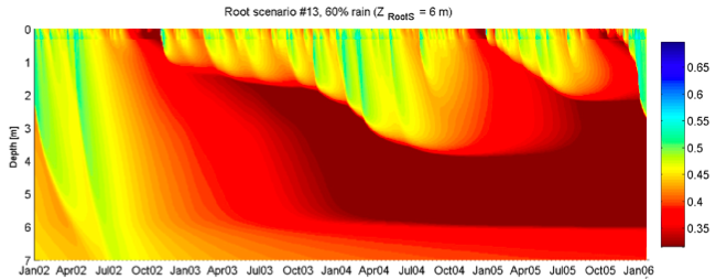
The above illustration shows the buildup of moisture stress at deeper layers as 60% of wet season throughfall is excluded from simulations. Trees with deeper root mass centroids would experience shortage of water, while shallow rooted trees are not stressed. Water uptake from shallow soil decreases its hydraulic conductivity, further preventing recharge of deeper soil layers.
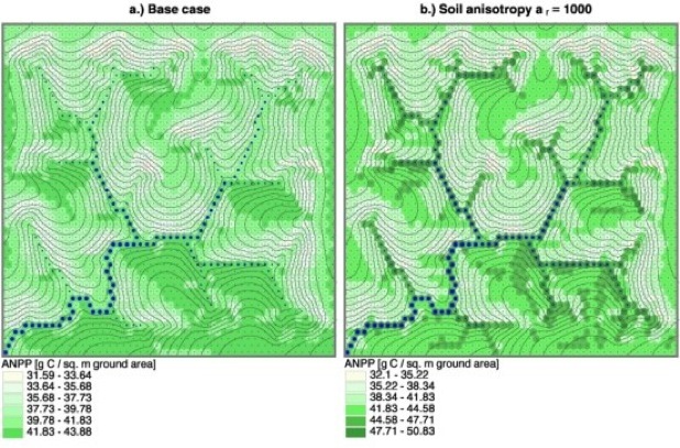
This modeling study focuses on vegetation-water-energy dynamics occurring in the complex terrain of a semi-arid area characteristic of central New Mexico. A set of numerical experiments is carried out for two small-scale synthetic domains that exhibit characteristic hillslope curvatures. A weather generator is used to create the long-term series of meteorological forcing. The linkages between terrain attributes and patterns of C4 grass productivity and water balance components are examined for three generic soil types: sand, loam, and clay. An attempt is made to characterize the structure of basin response by studying the spatiotemporal distribution of mean vegetation-hydrology variables averaged over the long-term simulation period. Principal hydrological regimes are identified, which are attributed to the magnitude of lateral water exchange in the domains of study. The analysis reveals that the influences of site-specific and non-local terrain characteristics are superimposed and their combined effect exhibits scaling properties. This allows one to link the characteristic vegetation-hydrology quantities at various landscape locations. Below is an illustration of the simulated patterns of Annual Net Primary Productivity (ANPP) for two selected modeling scenarios.
Topographic Controls on Vegetation Dynamics in Semiarid Areas
This study has been supported by the Graham Environmental Sustainability Institute at the University of Michigan through the grant “Assessment of the Impact of Watershed Changes on Estuarine Morphology and Aquatic Life”.
Hydrology “Up a Tree”
A recently initiated study was stimulated by (1) the heuristic nature of functions that constrain transpiration flux (reflecting plant water limitations) employed in the current generation of lans-surface and hydrological models; and (2) a lack of system-scale water stress signals even for driest conditions observed for such vastly different systems as the Amazon rainforest and Michigan temperate mixed forest. This study will combine in situ observations of plant micrometeorological environment, measurements of soil moisture over deep-soil profiles, sap flux observations, and leaf water potential for canopy-dominant trees.
The effects of canopy-scale heterogeneities on energy and soil water fluxes
Vegetation is heterogeneous at different scales, influencing spatially variable energy and water exchanges between the land-surface and the atmosphere. This study uses a high-resolution, physically-based ecohydrological model tRIBS + VEGGIE as a data integration tool to upscale the dynamics of spatially variable canopy resolved at a few meters to the watershed scale (~2 sq. km). A temperate mixed forest of Northern Michigan near the University of Michigan Biological Station is studied. Several scenarios of spatial variability of tree-scale leaf area and soil moisture were designed. The numerical experiments show that transpiration adjusts spatial variations of soil water to a distribution that is inverse of the canopy biomass variations, regardless of the initial moisture state. The aggregation of canopy-scale atmosphere-biosphere-hydrosphere interactions demonstrates a non-linear relationship between soil moisture and evapotranspiration that affects domain-averaged energy fluxes.
The video clips below illustrate the evolution of two initially different soil moisture patterns to the same ‘inverse-canopy biomass’ state, as determined by the same LAI distribution.
Downscaling of climate projections to a site scale: constraining projection uncertainty
The current ways of assessing the impacts of climate change on watershed systems are inadequate: they are based on an ad hoc selection of climate models; they focus on metrics at very coarse scales (hundreds-to-thousands of square km) detached from the reality of human activities and ecosystem services at the local (often the stream reach or floodplain) scales; and they do not yield any assessment of uncertainty associated with watershed modeling and projections into the future. This research aims to bridge the coarse-scale projections and the multi-scale, space-time connectivity of watershed systems, propagating information on climate signals through the entire watershed system: from headwater areas to stream channels, and to the details of flow characteristics. A comprehensive program of modeling and field observations is developed. The project will focus on the state of Michigan, where a number of observed metrics already demonstrate trends consistent with a warming climate, including shorter winters, higher mean annual temperatures, and higher frequency of heavy precipitation events. A number of case studies is developed along the state-wide gradient of climate and hydrological regimes. The premise used is that watersheds of 1st- to- 2nd orders can be used as “warning systems” (sentinels) of climate change for the hydrological regimes of drainage basins of higher orders. Multi-model ensembles of climate change projections from the World Climate Research Programme's Coupled Model Intercomparison Project are downscaled for the locations of these basins using an “in-house” stochastic downscaling methodology. The inferred probabilistic information is used to assess climate change impacts on watershed systems for early (2010–2039), mid- (2040–2069), and late century (2070–2099) periods.
This research is carried out in collaboration with Dr. Simone Fatichi at ETH, Zurich, Switzerland.
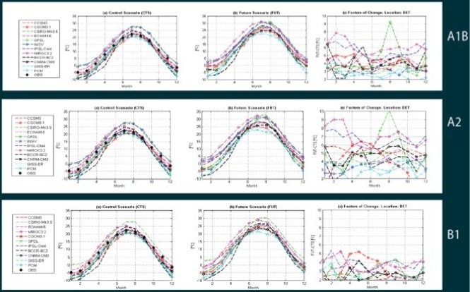
Downscaling: Air Temperature (Detroit)
Control: 1960-2000 Future: 2081-2100 Factors of change
Simulating land surface energy fluxes using a microscopic root water uptake approach
The predictive accuracy of current land surface models has been limited by uncertainties in modeling transpiration and its sensitivity to the plant-available water in the root zone. Models usually distribute vegetation transpiration demand as sink terms in one-dimensional soil-water accounting model, according to the vertical root density profile. During water-limited situations, the sink terms are constrained using a heuristic “Feddes-type” water stress function. This approach significantly simplifies the actual three-dimensional physical process of root water uptake and may predict an early onset of water-limited transpiration. Recently, a microscopic root water uptake approach was proposed to simulate the three-dimensional radial moisture fluxes from the soil to roots, and water flux transfer processes along the root systems. During dry conditions, this approach permits the compensation of decreased root water uptake in water-stressed regions by increasing uptake density in moister regions. This effect cannot be captured by the Feddes heuristic function. This study “loosely” incorporates the microscopic root water uptake approach based on aRoot model into an ecohydrological model tRIBS+VEGGIE. The ecohydrological model provides boundary conditions for the microscopic root water uptake model (e.g., potential transpiration, soil evaporation, and precipitation influx), and the latter computes the actual transpiration and profiles of sink terms. Based on the departure of the actual latent heat flux from the potential value, the other energy budget components are adjusted. The study is conducted for a northern temperate mixed forest near the University of Michigan Biological Station.
The simulation below illustrates soil moisture dynamics for slices of a 3-D soil domain 5 m x 5 m x 2 m. Initial drying due to water uptake by roots is interrupted by rainfall events. Continued drying below the tree stem leads to low water potentials.
This research is carried out in collaboration with Dr. Christoph Schneider and Prof. Anke Hildebrandt at Helmholtz Centre for Environmental Research-UFZ, Leipzig, Germany.
This material is based upon work supported by the National Science Foundation under Grant No. 0911444 and by the Streeter Fellowship at the University of Michigan to Lingli He.

This material is based upon work supported by the National Science Foundation under Grant No. 0911444.

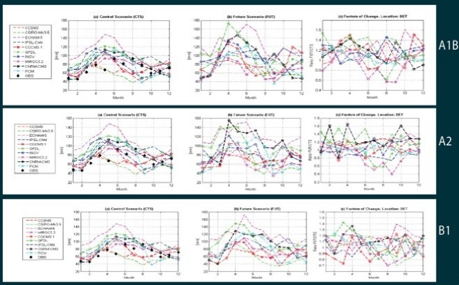
Downscaling: Precipitation (Detroit)
Control: 1960-2000 Future: 2081-2100 Factors of change
This material is based upon work supported by the National Science Foundation under Grant No. EAR 1151443.
