2000
Census data on segregation in New York.
(Provided by the Lewis
Mumford Center for Comparative Urban and Regional Research.)
| New York, N.Y. | ||||||||
|
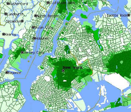
The maps in this section, Racial Segregation in the U.S., were produced using the U.S. Census Tiger Mapping Service, which permits users to map 1990 Census data to any part of the U.S., on any scale. 2000 Census data for income were not available at the time these maps were made. Other 2000 demographic data were not available through Tiger, and hence were difficult to map. Racial demographics in major metropolitan areas have changed only marginally since 1990, however, so the maps here are still broadly accurate. | |||||||
|
2000
Census data on segregation in New York. |
||||||||
| The maps for New York, N.Y. illustrate the structure of the segregation maps. The default setting for these maps shows the % of the population in each census tract that is Black or African-American, because this is the most highly segregated of all U.S. racial groups. Move your cursor over the other blocks to find the %Asian-American, %Hispanic/Latino, and %White in each census tract. Move your cursor on the %Black block or anywhere off the other blocks to return to the default setting. Dark green indicates very high concentrations of the selected racial/ethnic group; white indicates no presence of that group; pale green very low presence. Some city pages may not show certain groups if their concentration in that city is uniformly low. Move your cursor over the Income block to find median family income in each census tract. Notice that the legend changes when you do this. Although absolute income figures are not current, the relations among census tracts (rich = dark green; poor = white and pale green) have not changed much in the 2000 Census. To observe the relation of racial demographics to income, move your cursor rapidly between the income and demographic blocks. The Lewis Mumford Center offers extensive graphical and tabular presentations of 2000 Census data on racial segregation. | ||||||||