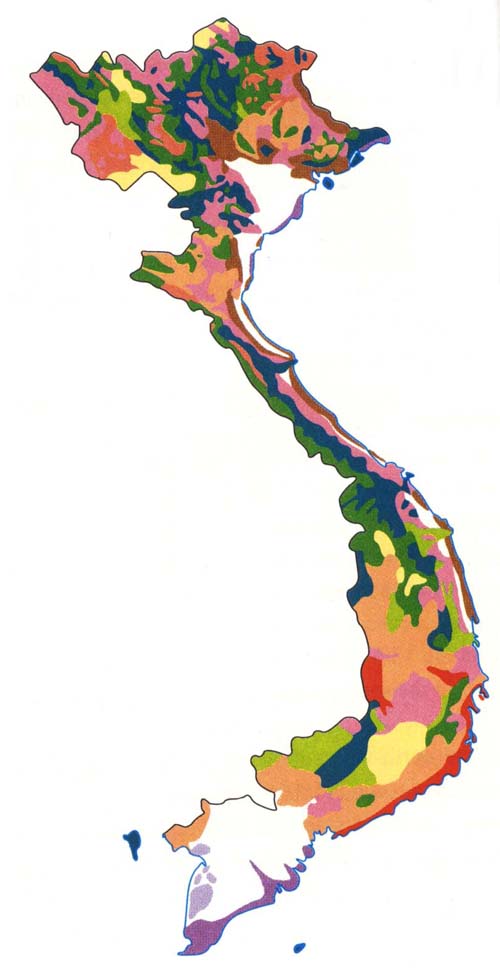
Map: Major Vegetation Zones
Color Key: Types of Vegetation Secondary Forest and Bamboo
Forest Dense Evergreen Forest
Secondary Savanna Dense Deciduous Forest and Clear
Forest Dry Mountain
Formations Savanna Artificial Reforested
Area Dense Evergreen Mountain
Forest Coastal Mangrove Forest
& Secondary Mangrove
Forest Mixed Dense Forest and Clear
Mountain Pine Forest Agricultural
Areas
Map: Major Climatic Zones

|
Color Key: |
|
|
Subequatorial Dry |
Tropical Wet |
|
Subequatorial Subdry |
Tropical Subwet |
|
Subequatorial Subwet |
Subtropical Wet |
|
Subequatorial Wet |
Subtropical Subwet |
|
Tropical Dry |
Temperate Wet |
|
Tropical Subdry |
----------------- |
General Description:
Three-quarters of the country consists of mountains and plateaus which are an extension of the highlands of southern China and the Indochinese peninsula. A string of small plains in the narrow stretch of land between sea and mountains are found along the coast in the Center. The only fairly large plains occur in the deltas of the two large river deltas flowing into the South China Sea: the Song Hong (Red River) in the north and Cuu Long (Mekong) in the south.
The wide variations in climate are due to the mountainous relief, the difference in latitude and coastline extending 3,000 km from north to south: temperatures decrease with altitude while precipitation varies according to the influence of the monsoon rains. Although the hot and wet intertropical climate due to the summer monsoon predominates, eleven different climatic types can be identified, ranging from subequatorial dry to humid temperate climate.
The forest cover is also characterized by diversity, even though dense evergreen monsoon forests predominate. It varies from intertropical in the plains and piedmonts to subtropical in the mountains while woodlands and savannas predominate in the drier regions. Shifting cultivation, the exploitation of forests, and defoliation during the war have resulted in the development of increasingly sparse and xerophitic secondary formations.